“I believe that this boundary we’ve created between humanity and our environment is artificial,” says Bradley Cantrell, a computational landscape architect. Photo: Ryan Lash/TED
Picture a spillway gate that doesn’t just release water from an overflowing river, but manipulates sediments to create new streams, islands and wetlands. And imagine that the gate does this autonomously, guided by ecological data and shifting needs — essentially allowing nature to “evolve.” Computational landscape architect Bradley Cantrell is figuring how to do this by applying environmental sensing, machine learning, predictive modeling and robotics to environmental engineering.
The TED Blog asked Cantrell to talk to us about his ideas, how they would work, and how computational landscaping may change the relationship between human beings, machines, and nature.
What is our current relationship to the natural environment, and how do you envision changing it?
Right now, human beings are really good at saying, “We want this river to move very quickly, and we want it to always be predictable.” So we can engineer a predictable river. Take the Los Angeles River, which is a simple example. It’s basically a concrete channel. We’ve taken all the unpredictability out of it because it used to jump its banks and flood a large part of the Los Angeles River basin. We said, “We want it to be within this 20-meter-wide zone and to never move, and we want it to always run at the same velocity so it never backs up and floods anything.”
But that’s not the way an ecosystem or river works. It actually has a whole range of behaviors. We currently don’t allow these systems to have a range of behaviors. I would like to change this so that our infrastructures allow the creation of evolving and changing ecosystems.
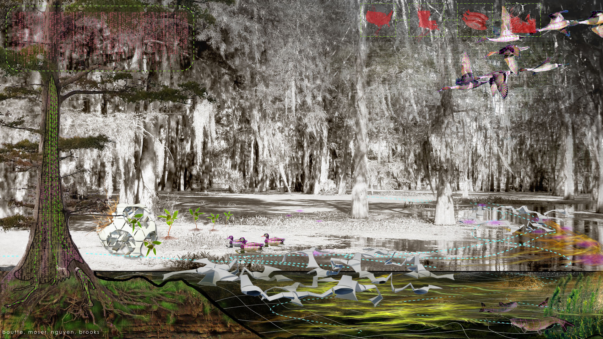
A diagram of landscape monitoring and synthesis. Image: Joshua Brooks, Devon Boutte, Martin Moser, Kim Nguyen
Where does the idea of computational landscape architecture fit in?
Computational landscape architecture is the idea that, using computing and machine learning, we can build physical infrastructures and natural landscapes that relate symbiotically with our cities and natural systems.
In theory, what we’re doing is embedding the complexity that exists in natural ecological systems into our own manmade environments. We do this by feeding computers data from natural historical records. So, for example, you might have a set of records about how a particular ecosystem performed, such as the behavior of a river’s water levels and velocity. Then you might have a series of predictive models, about how sea-level rise due to climate change will affect this local ecosystem, for instance. These predictive models are used to develop a computational logic which allows them to make autonomous decisions about how it uses infrastructure — like spillway gates — to prevent possible problems.
This means that computers end up having a life of their own, within our design goals. Machine learning can be compared to how we make decisions: we make choices for the future based on data from experiences we’ve had in the past.
In your talk, you offered the example of the Mississippi River, for which you’ve prototyped a computational infrastructure. Walk us through the process of how it would work.
The example I most often give is a system of spillway gates that, instead of simply allowing river water to flood a lake when it gets too high, precisely controls the flow of water to create landscapes that benefit biodiversity or protect cities from storms — and does so in an automated way.
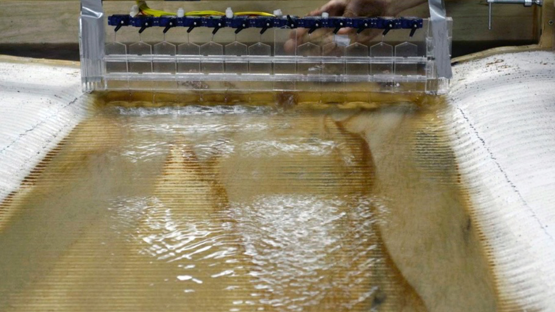
A prototype of the robotic spillway gate, which automatically distributes sediments according to computational instructions. Project: Bradley Cantrell, Justine Holzman, Prentiss Darden
The Mississippi River has always jumped its banks. If you look at the shape of Louisiana, its shape is the result of the sediments in the floodwater building out land. Left to its own devices, once the river finds its longest route, it jumps its bank and tries to find a shorter route. Rivers naturally do this kind of cycling.
In the last 100 years or so, we’ve built levees all the way down the river. If you look on a map, you’ll see the Mississippi River now has this really long route, and it’s just continued to build and build and now its dumping dirt off the continental shelf into deep ocean water. There’s actually a shorter route for the Mississippi river: it naturally wants to jump its banks and go down what’s called the Atchafalaya Basin. The US Army Corps of Engineers built a structure where it wants to jump, forcing it to go the long way.
Why? Is it because people are there?
No. The Atchafalaya Basin could easily be flooded, with few consequences. But New Orleans sits further downstream, and if you change the route of the Mississippi River, suddenly New Orleans becomes completely irrelevant in terms of a city. It would be sitting out in this exposed area with no river next to it. So for the sake of commerce, we still want ships to come through. There’s all kinds of mega-engineering going on to keep that river the way we want it to be.
The problem was, in the past the levee would just break down in certain areas and start to flood out into the bayous. This happens whenever the river is very high. It breaks free in certain areas and it just floods, and all of this dirt carried down from Iowa and St Louis dumps out into the area, basically replenishing the land there. People have said, “Well, we should just begin to build massive gates on the river, and whenever the river gets to be too high, we’ll relieve the pressure by flooding these areas.” So the safety aspect is already in place. There are two spillways: one of them floods the whole Atchafalaya Basin, and the other one floods Lake Pontchartrain, north of New Orleans.
Those projects were both built in the ’50s and ’60s, right after they forced the river into its current configuration. But these solutions haven’t been about pushing water into land we want to build. They’re pushing it into places that we then have to go back and dredge out so that the Ponchartrain can still be a lake, and the Atchafalaya Basin can still be a river.
Above: Watch Bradley Cantrell’s spillway gate “print” a landscape by controlling the flow of sediment-laden water.
With your solution, what would happen?
I’m adding a layer to this. Let’s say we go ahead and open up these spillways in a range of new locations that are already being proposed. What if each of those spillways had a whole range of things it could do, rather than simply flooding or not flooding? And how can we speed up or slow down the velocity of the water coming through? The answer is by opening these gates in different sequences. Think of the way you put your finger over a water hose. When we slow the flow down, sediments fall out of it, and by speeding it up, it carries sediments further, or breaks obstacles down and pushes beyond them.
So just using those two mechanisms, we plan to push the water and the dirt to go where we want it to go. If we have control over the land-formation process alone, we can start making choices about whether ecosystems should evolve in a certain way, and we can help nudge things in that direction. Once the system is fully functioning, it would form landscapes on its own, but it will have had our curatorial help.
Can you give us an example?
If we know, for example, storms have come into Louisiana in a certain way 80% of the time throughout history, it’s logical and possible that we could form that land so that it provides the greatest barrier to such storms. Or if we know sea-level rise is happening at a certain rate, the system could respond by forming the land in such a way that we’re future-proofing that area for, say, the next 25 years or so.
What about plants and animals in this ecosystem? How would you control the health of biodiversity and habitats? Is this really controllable?
Ideally, as these systems are being built, habitat formation and biodiversity protection would be given equal weight to protection from storms, climate change, and so on. So we ask, “What are the sizes of the habitats for certain animals? What are the soil depths and soil compositions we need for specific plant material?”
Does this mean you’d actually go out there and plant things?
No, ideally plants would be naturally seeded. There’s not a lot you have to do in the Delta to get plants to grow. They’ll just pop up if there’s any land that forms. But you can take into account that certain grasses need to be a particular depth out of the water, for example, or there are certain trees that only take root at particular depths because they have to be dry at certain times of year. By engineering the soil profile, you basically set the canvas up for those plants to come in and have a place to grow. We’re building a scaffolding for these habitats to take over naturally.
So we’re changing the relationship between spillways that act only as a safety valve, to actually curating and managing a whole ecosystem as part of the natural extension of the river.
Above: Watch an animated visualization of how a sediment gate would work. Credit: Louisiana State University Coastal Sustainability Studio
This project is huge in scale. Is this all theory at this point?
At the moment, I’m working only with digital or physical simulations. But these next steps really are coming online for the Mississippi River. For example, they’re already thinking about the way sediment gates are sequenced, how they open and close. While it’s not yet completely autonomous and robotic, that type of logic is already being considered. And there’s a whole set of things that come up with that, in terms of do we just say this is the landscape we want on the other side of this gate, and then we force it — or do we try to develop more complex relationships within the ecosystem?
Are you working on any other case studies?
There are some interesting things coming out of student projects we’ve done. Two students recently modeled a solution for particulate matter in West Oakland, California. One of the big issues in this area is that idling diesel trucks on the freeway, which runs along the edge of West Oakland. The trucks create a huge amount of diesel particulate matter. At the same time, there’s a breeze coming in across the San Francisco Bay, which takes all of that pollution and dumps it in West Oakland. Because it’s so dry there, the particulate matter actually floats much further than it would in many other places.
As a solution, the students designed an irrigation device — something that looks like a light post, but which sprays a mist of water. They proposed to “plant” these in a series of very narrow strips in disused areas of the city. Making the air very humid in those strips would stop the particulate matter and allow it to drop in place, rather than getting blown over people’s homes. At the same time, the moisture would allow trees and other vegetation to grow, which would help absorb the pollution. These filters could also be cycled off and on, so once the plant material is overloaded with pollutants in one strip, you could bring the humidity down, allowing another filter further inland to do the job, and allowing the plants to recover.
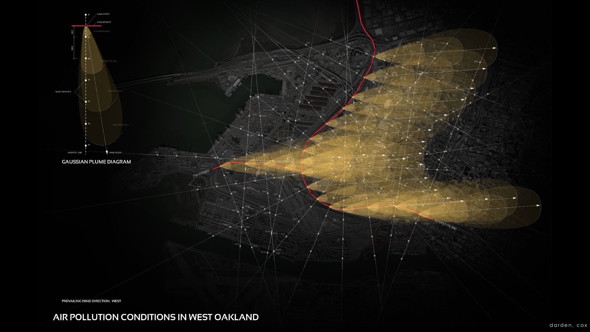
An analysis of particulate matter traveling over West Oakland. Image: Prentiss Darden, Silvia Cox
What was your way into this line of innovation? Did it grow out of a passion in engineering? Architecture?
My undergraduate education was actually very long — longer than it should have been, as I tried to figure out what I was going to do! I started in painting and illustration, and then I went into computer science for many years, and then I got into landscape architecture when I started studying plant biology and developed an understanding about environments and ecosystems. But I always had this background in visualizing, painting, making imagery, as well as the computational background, so those two came together.
When I ended up at Harvard to get a post-professional degree in landscape architecture, I studied interactive spaces and data visualization. This concept of interactive spaces — which we now call responsive environments — really helped to develop methods to understand how computation and the environment could communicate to each other. That got my interest piqued. I started asking what these new technologies were, and how we were using them. How could they be applied to landscape? And what would it mean to embed computation in landscape? After all, it’s in our phones, it’s in our architecture, it’s in our cars. What might happen if it started to drive our landscapes and natural environments?
If this idea takes off, we could have computers evolving what we consider our “natural” environment. Have you thought much about how this blurs the line between nature and the built environment? Are there down sides?
I believe that this boundary we’ve created between humanity and our environment is artificial. It’s a construct that we use because we place ourselves at the center in our perception of the world. Our goal should be to erase this line and to consider ourselves as equal actors within the environment. This actually requires us to back away slightly and consider a range of environmental influences — not just human needs.
Our current attempts are typically about conservation which cripples us and sets up a confrontational atmosphere of humans and the “natural.” This also creates methods of construction which force us to remediate rather than work with the environment and learn from it over time. We also have to come to terms with the fact that ecosystems evolve and change. We can’t be in love with their current state. What we can fall in love with is their richness — and then design and curate this, in new and varied forms of novel ecological systems.
Having said that, there are certainly negative possibilities. The more we embed our technologies within the environment, the more control we grant ourselves, which can often turn out badly. In many ways, it requires us to evolve intellectually. If we can take a more humble approach to the planet, we’ll find ways to not only surpass our current limits of construction and evolution, but bring a rich and evolving ecosystem with us.

A metabolic forest — narrow strips of disused land planted with vegetation and water misters — would act as a filter against air pollution floating over West Oakland from nearby freeways. Image: Prentiss Darden, Silvia Cox
Comments (7)